This facility automatically generates the complete formation surface for your entire site design.
The formation surface is comprised of the finished design surface with trenches cut out below all the design items, according to the necessary depth which would be required to be dug out under each type of design item before constructing it on site.
This one-click feature saves a huge amount of time, as producing this surface using other tools is a very complicated and time consuming process.
To create the formation surface click on the Create Formation Surface button ![]() on the Surfaces and Volumes toolbar
on the Surfaces and Volumes toolbar ![]() .
.
When you select the Create Formation Surface option, a new submodel will be generated with the name Formation Surface. You will see the Formation Surface model in the layers window along with the other submodels you may have imported into the project.
Each time you select the Create Formation Surface option, the Formation Surface model will be updated to reflect the current state of the site design.
This submodel surface can be visually displayed with cut and fill height banding options.
You can also use the surface with the Surface->Volumes... facility to generate an isopachyte drawing of the cut/fill differences between the formation surface and the existing ground surface.
In order to define the extent of the formation surface, it is useful to indicate the site boundary.
You can do this by digitising a line around the known site boundary using the New Centreline tool and then levelling the centreline to the existing surface (using the Road->Centreline Extras->Level to Surface... menu option).
The formation surface model can now be used to make a cut and fill volumes comparison with the existing ground surface.
The formation surface properties window allows you to control what items are used to generate the formation surface, and allows you to specify the construction depths of those items.
This is accessed by clicking on the Formation Surface Properties button ![]() on the Surfaces and Volumes toolbar
on the Surfaces and Volumes toolbar ![]() .
.
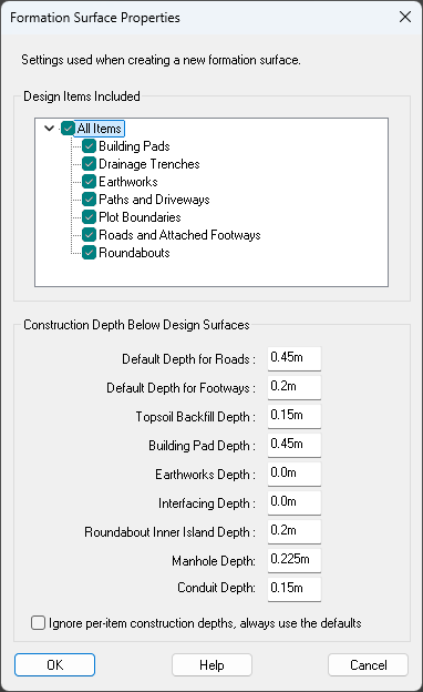
The settings for Default Depth for Roads/Footways specify the default depths for any road or path that has not had a specific construction depth set. The default depths are overridden if you set the construction depth per-road/path using the Channels/Kerbs/Footways window.
If you tick the Ignore per-item construction depths, always use defaults box, the default depths will be used for all items when creating the formation surface, overriding any manually set construction depths. Ticking this box will not change any of the construction depths that have been set in the design model.
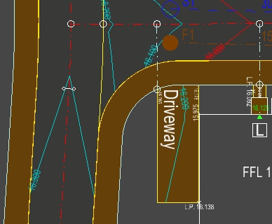
The Topsoil Backfill Depth is the construction depth that will be returned to beyond the outermost edge of design items. This is shown in the image below in the empty space to the left of the driveway: