Calculate the storage estimate of a proposed site by running a SWMM drainage simulation on a representation of the site. The site is simulated as a single large catchment area that flows at a restricted Greenfield Runoff rate to an outfall. The volume of water that would have flooded the site is the volume of estimated volume of storage required.
The Greenfield Runoff rate is calculated using the IH124 method for a 1 year return period storm using the Site Area, Hydrolic Region, Soil Type (Winter Rainfall Acceptance Potential) and SAAR (Standard Annual Average Rainfall) values.
On the ![]() drainage auto-sizing-levelling and simulation toolbar,
click the
drainage auto-sizing-levelling and simulation toolbar,
click the ![]() Quick Storage Estimate... button.
Quick Storage Estimate... button.
After clicking on the Quick Storage Estimate... button you will see the following window appear:
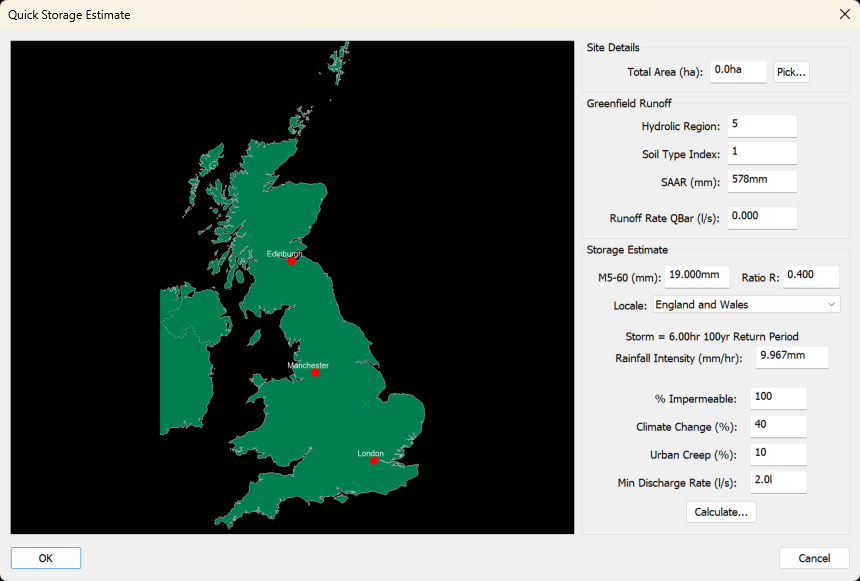
If you know the plan surface are of your site, you can type in the value in the Total Area box. If you don't know the area, you can calculate it by clicking the Pick... button and digitise a site boundary line. After you have drawn the site boundary line, right click and choose Finish to return back to the Quick Storage Estimate window.
The Hydrological region index is from FSSR 14 and is in the range [1 to 13]. The Soil Type is the WRAP map of SOIL type from the Wallingford Procedure and is in the range [1 to 5]. The Standard Annual Average Rainfall (SAAR) is the average annual rainfall in mm, usually obtained from Flood Studies Report.
Click on the map to choose the M5-60 and Ratio R FSR information for your site location, or manually type in the FSR M5-60 and Ratio R values and choose whether the site Locale is England and Wales or Scotland and Northern Ireland. The average Rainfall Intensity will update to show the value for the current values chosen above. If you have a specific intensity you want to use, simply type the value into this edit.
The % Impermeable (PIMP) value is a percentage of how much of the Total Area will be impermeable, like roads, house roofs and driveways.
The Climate Change % is the projected increase in rainfall intensity and Urban Creep % is the projected increase in impermeable area over the lifetime of the site.
If the calculated Greenfield Runoff Rate is lower than the Minimum Discharge Rate, the Minimum Discharge Rate value will be used in preference to calculate the storage estimate instead of the Greenfield Runoff Rate.
Click the Calculate... button to use the values entered above to see a window showing the estimated storage requirements for your site.