You can open an existing 2D or 3D drawing with the File->Open... menu option.
Alternatively, you can click the ![]() toolbar button, or press the Ctrl+O on the keyboard.
toolbar button, or press the Ctrl+O on the keyboard.
You will see the standard window for selecting a file:
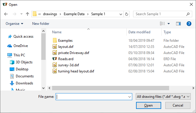
Select the file that you want to open.
You can restrict the type of files that you see by using the Files of type: drop-down list.
NOTE: you can enter any kind of URL for the file name. For example http://www.topogx.com/samples/pond.dxf will pull a sample file straight off the web.
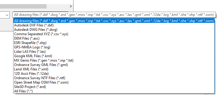
The following files types are loaded by Site3D:
This is an industry standard file format for drawing exchange. The DXF file format originates from AutoDesk Inc. for their AutoCADTM product line, but nearly all CAD related software will load or produce a DXF file. Site3D will load all versions of DXF file, right through to the latest AutoCAD release.
Note: To import DWG format files it is necessary to have the free DWG/DXF Converter application installed. If you have not yet installed the converter, you will be prompted to do so when you try to import/export a DWG. It will offer to show you the web-page where the converter can be downloaded for install. After installing the converter, DWG export and import will operate seamlessly.
This is raw X,Y,Z point data in ASCII format. The format is assumed to be in X, Y, Z ordinate order with a comma separator between. It is also assumed there is only one coordinate per line. Some DEM files may be in this format which stores the points in a regular grid pattern. Alternatively, the points may be non-regular point-cloud data.
Example:
354999.915, 183847.234, 8.429For Digital Elevation Models (DEM), including DSM and DTM variations. This file format holds height level data in the form of a regular grid of points. There are quite a few different variations on this file format. If you find one that does not load in Site3D then please e-mail us so that we can add support for it. DEM data is more commonly used in the GIS industry than the CAD industry.
The Shapefile format is used widely in the GIS (Geographic Information Systems) industries. The CAD type data (for example, lines and regions) will be imported from the Shapefile.
This file format is usually generated by GPS equipment as a location log and contains the NMEA GPS 'GGA' sentences read directly from the GPS device. Site3D will import the point locations in this file as a series of points in a polyline indicating a route.
Example:
$GPGGA,123519,4807.038,N,01131.000,E,1,08,0.9,545.4,M,46.9,M,,*47Lidar systems usually create a cloud of 3D points from the laser ranged surface. Site3D loads this data and forms the 3D surface model.
Geometry added by Google Earth can be loaded into Site3D. If the model is within UK lat/lon then it is automatically converted to the equivalent UK Ordnance Survey coordinates.
This file format originates from the Bentley MXTM system (formerly Moss).
This is the GENIO model format that MX loads and generates.
There is very little feature information in a GENIO file,
but Site3D tries to assign to different drawing layers based on the 4 character string labels that are present in GENIO files.
The GENIO model can look a lot better in the 3D view of Site3D than in MX (Site3D will also display it very much faster),
so you may find Site3D very useful for visualising your MX project data.
GML is an alternative format to DXF for digital vector mapping drawings from the UK Ordnance Survey. GML has the advantage of retaining the coloured regions representing the differing land usages, and so generally produces a more visually pleasing drawing than the equivalent DXF from the OS.
Note: you can use Site3D to load a GML file and output as a DWG or DXF retaining the same visual appearance.
This format is one of the industry standard formats for exchanging terrain and drainage data and contains geometry in an XML format.
This file format originates from the 12d Solutions Pty Ltd system. Site3D will load various topographical elements from this format as well as importing alignments as designed centrelines.
This file format originates from the www.openstreetmap.org mapping system. If you export an area to an OSM file, you can load this into Site3D as vector data with the different topographical features on different layers.
For Digital Elevation Models (DEM), including DSM and DTM variations. This file format holds height level data in the form of a TIFF image with embedded geographic information. There are a few different variations on this file format. If you find one that does not load in Site3D then please e-mail us so that we can add support for it.
This is the native file format for Site3D. An ERD file holds all the project's information, including any data that was loaded from other sources. If you have already opened a Site3D project this option will open the newly selected project into a separate tab.